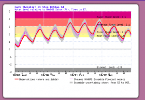
http://hudson.dl.stevens-tech.edu/sfas/d/index.shtml?station=U226
A number of our members live in Surf city. When we hear an alert for “coastal flooding” what does that mean? The above URL and the information below will help people compare a flood forecast to the reality of the unusually high tides resulting form wind and weather. Here we show a picture of flooding as a specific location and the Stevens Institute Flood Advisory System.
This example resulted from a low pressure system that was in the area around Wednesday 10/9/19. It caused the highest water 10/11/19 and 10/12/19. Note that this event is in the middle of the Moderate Flood Level. For 7th street in Surf City, that means as high as a pick-up-truck can navigate with maybe 3 more inches of leeway.
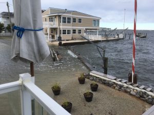
The result during the dead high tide 10/11/19 was about 5 inches of water in my garage 357 North 7th. This picture shows the water over-toping the bulkhead at 3:00 PM, Low tide was 6:11 PM and High Tide was 11:15 PM.
Recent Comments